THE ROMAN EMPIRE IN GALICIA
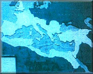
The first photograph shows the beginning of the Empire, 8 th century BC.
During the year 139 BC, Quinto Servilio Cepión's expedition took place. A bit later, Décimo Xunio Bruto's journey to these areas, in 137 BC, was more important. He advanced from the "River Tajo" to the "River Duero", where the "Duero's Battle" was carried out. He moved forward towards the north until he crossed the "River Limia" ("Lethes", "Oblivionis Flumen" or "Forgetfulness River") in Gallaecia and proceeded until he got to the "River Miño" side. According to the legend, he felt a terrible fear when he saw the sun setting down into the ocean and came back to Rome.
During the years 96-94, Publio Craso set off on a new commercial expedition and the way to Galician tin was opened. After this journey, foreign materials were more frequent. It shows the importance of foreign trade, mainly shipping trade.
During the years 60-61 BC, a punishment expedition was carried out by Cesar. He needed fame and money and so he embarked on an incursion towards the north, helped by the family "Balbos de Gadir" in his journey by sea. We don't know much about this new expedition but he certainly got to Brigantium, in the "Artabro Gulf', (Ferrol, Betanzos and Coruña Firths). Apparently, this expedition contributed to consolidate an old trade way previously known.
Augusto became Emperor in the year 27 BC. Due to political and economical reasons, he decided to conclude the conquest of the "Peninsula Ibérica". The main stage in this fight took place between the years 25 and 19 BC.
Agripa got rid of the resistance spots and set up a first organization of the territory.
Between the years 15 and 13 BC, Augusto came back to Spain ( Hispania). He probably arrived at Asturica, an old military camp for his troops, where he gave this territory to the people living in the place, ("indigenous"), to serve as the capital.
During that time, the territory that formed
Gallaecia was excluded from the province of "Lusitania" and included in
the province of"Citerior".
The "Conventus" in Gallaecia were:-
"Conventus Lucensis": capital city, Lucus Augusti
(Lugo). It included all the land to the north-west in the "Peninsula Ibérica".
It was limited by the "Firth of Vigo", the rivers "Verdugo" and "Sil" and
the "Suido" mountain range, to the south; by the "Courel, Ancares and Rañadoiro"
mountain ranges and the lower and middle parts of the river "Navia", to
the east. All this means that it included most of Galicia as it is today.
-"Conventus Bracarensis": capital city, Bracara
Augusta, (today Braga, in Portugal). Its frontiers were: to the north,
"Coventus Lucensis"; to the west, the "Atlantic Ocean"; to the south, the
"River Duero"; and to the east, it was separated from "Conventus Asturiacensis"
by "San Mamede and Queixa" mountain ranges.
-"Conventus Asturiacensis": capital city, Astúrica
Augusta, (today Astorga, in León, another Spanish region). This
"Conventus" was limited by the "Cantábrico Sea", to the north; by
the "River Esla" and the "River Cea" until this one flows into the "River
Duero", to the east; and by the "Conventus Lucensis and Bracarensis", to
the west.
The purpose assigned to each "Conventus" was
different: Asturiacensis served a military and economic-administrative
purpose; Bracarensis was more involved in religious and commercial items;
and Lucensis shared a mixture of all these purposes but it probably had
less Roman influence than the other "Conventus".
The influence that the Roman Empire exerted
on Gallaecia was a long difficult process. It was different to the rest
of Hispania because the inhabitants of this area were also different to
the rest. This process cannot be understood under Mediterranean parameters
but looking at the schemes of other provinces included in the Empire.
This fourth photograph shows how much of Europe,
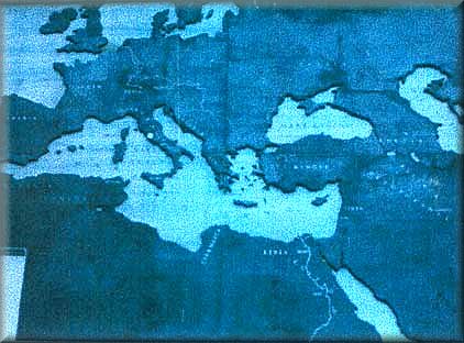
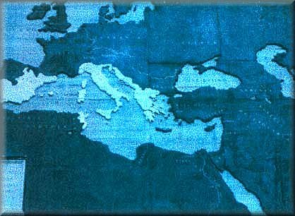
north of Africa and other areas had been conquered at Trajano's time.In this third photograph one can see that Gallaecia
(Galicia) had been conquered as well as Gallia (France) and Tracia (Romania).
It shows the Empire at the time of Augusto's death. 
Much later, Diocleciano, (in the year 305
AD), reorganized the administrative, economic and military structure of
the Empire by creating "Prefecturas de Diócesis", (one of them would
include all Hispania and the North of Africa), and "Prefecturas de Provincias",
(one of which would be Gallaecia). At that time, Gallaecia got its maximum
length, including those territories between the "Cantabrico Sea" and the
"River Duero" and those between the "Atlantic Ocean' and the "Sistema Ibérico"
mountain range. Inside the province of Gallaecia, there was also one more
division: the "Conventus". They were composed of a defined territory with
a capital where fiscal taxes, economic and financial management, official
religious worship and military control were centred.