
Urban planning in Thessaloniki
The shape that Thessaloniki had during the first two centuries since it was first established (3rd and 2nd century BC) is almost unknown to us and practically lost forever. Even most of the findings we have from the numerous remaining excavations in the last twenty years, derive mainly from "outside the wall" areas connected with the cemeteries. The excavations which precede the construction works in the building sites in the center of the city, have given us very few and uncertain relics of Hellenistic buildings, already destroyed by the intervention of the Roman and more recent years and technically unapproachable due to huge landfills. Despite all these, relatively recent studies of Thessaloniki's street layout before the city was destroyed by fire in 1917, in connection with the scant excavation data, show that at least in the city center the urban planning of the ancient Thessaloniki was retained.
The urban planning of Thessaloniki, which started in Hellenistic years, is adopted by the Romans and it is rapidly developed; moreover, its basic characteristics coincide with the equivalent of the Roman system.
Towards the close of the 3rd century, Thessaloniki recovers under the governing of the first tetrarchy. The new construction era is characterized by the expansion of the city limits and Galerius Maximianos' magnificent palace. Therefore, in a place parallel to the financial - commercial center (Forum) the palace is built and at the same time Rotunda and the Hippodrome, in close relation and proximity to the port. The eastern section of Thessaloniki becomes the center of administration and control of the whole province.
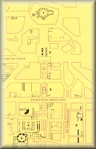
Map of the center of the modern city with all the important Roman monuments (except the Roman Forum)
1. Rotunda
2. Galerio's Arch
3. Ruins of unidentified building
4. Galerius' Palace
5. Octagon
6. Hippodrome